Welcome to some of the world's most magnificent mountain walks and hikes! Whether you are looking for one memorable afternoon stroll, or series of high mountain adventures, "The Walking Guide" presents to you much of Zermatt's stunning best. If this is your first visit, before anything else, please bookmark this page so you may return here at your will. You are welcome to print out these pages for your own personal use, otherwise all text and images are © ski-zermatt. Enjoy browsing and planning your visit to this beautiful mountain walking area. Look at all the walks at a glance, read some recommendations, look at some visual highlights (photos) of the walks, or jump to the large map for orientation. Disclaimer: Although the author and ski-zermatt.com try to make the information in The Walking Guide as accurate as possible, we accept no responsibility for any loss, injury or inconvenience sustained by anyone using this guide. New - The Walking Guide now includes a
fantastic supplement for users of Google Earth. Get it here. |
 |

At a Glance - Walk Facts and Figures
| Name of walk | Highest | Popularity | Difficulty |
Hours of walking |
Where? | Where? | Lift | Trail Open | Trail features | Highest | Name of walk | ||
| Villages & forests | Altitude | Up | Down | Total | Starts at: | Ends at: | Costs | Altitude | Villages & forests | ||||
| Easy forest walk | 1720m | **** | * | 1/3 | 1/3 | 1 | Zermatt | Zermatt | None | Year round | Forest, views | 5660ft | Easy forest walk |
| Zum See & Blatten | 1770m | **** | * | ½ | ½ | 1 | Zermatt | Zermatt | None | May-October | Villages, restaurants, forests, gorge | 5820ft | Zum See & Blatten |
| Zmutt | 1936m | ***** | ** | 1¼ | 1 | 2¼ | Zermatt | Zermatt | None | Year round | Village, restaurants, flowers, views | 6370ft | Zmutt |
| Tufteren | 2288m | ***** | * | flat | flat | 1 | Sunnegga | Sunnegga | sFr.24 | May-October | Village, views, forest | 7530ft | Tufteren |
| Findeln | 2070m | **** | ** | 1½ | 1 | 2½ | Zermatt | Zermatt | None | May-October | Village, restaurants, views | 6810ft | Findeln |
| Edelweiss | 1961m | *** | *** | 1 | ¾ | 1¾ | Zermatt | Zermatt | None | May-October | View, restaurant | 6450ft | Edelweiss |
| Mid-Alpine rambles | Mid-Alpine rambles | ||||||||||||
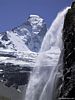
| Höhbalmen | 2743m | ** | *** | 3 | 2¼ | 5¼ | Zermatt | Zermatt | None | June-Oct | Stunning views, waterfall, wildlife | 9025ft | Höhbalmen |
| Gornergrat descent | 3130m | **** | *** | 3 | 3 | Gornergrat | Zermatt | sFr.43 | June-Oct | Super views, lakes, forests | 10300ft | Gornergrat descent | |
| High mountains | High mountains | ||||||||||||
| Hörnli hut | 3260m | *** | **** | 2½ | 1½ | 4 | Schwarzsee | Schwarzsee | sFr.50 | Jul-late Sep | Classic hike to base of the Matterhorn | 10725ft | Hörnli hut |
| Schönbiel hut | 2694m | ** | *** | 4 | 3¼ | 7¼ | Zermatt | Zermatt | None | Jun-October | Matterhorn views, waterfall, glaciers | 8860ft | Schönbiel hut |
| Rothorn hut | 3200m | * | **** | 4 | 3 | 7 | Zermatt | Zermatt | None | Jul-late Sep | Views, glaciers, a remote trek | 10530ft | Rothorn hut |
| Mettelhorn* | 3406m | ** | ***** | 5½ | 3½ | 9 | Zermatt | Zermatt | None | Jul-late Sep | Stunning 360° panorama, 'long' trek | 11205ft | Mettelhorn |
| Ober Rothorn | 3415m | *** | **** | 1½ | 1 | 2½ | Unter Rothorn | Unter Rothorn | sFr.67 | Jul-late Sep | Stunning 360° panorama, 'short' trek | 11235ft | Ober Rothorn |
| Orientation walks | Orientation walks | ||||||||||||
| Around Zermatt | 1620m | ***** | * |
flat |
flat | 20min | Zermatt | Zermatt | None | Year round | Town highlights and useful locations | 5330ft | Around Zermatt |
* Future projects. Difficulty: The more stars given to
difficulty, the steeper and more strenuous you can expect a walk to
be. Extra stars are given for those hikes requiring particular care or
preparation. Read each walk description for specific details. A walk of
one or two stars difficulty could be accomplished by any able-bodied
person,
including children. A three-star-difficulty walk requires a reasonable level of fitness
and preparation : expect steep grades and plenty of steps, so regular exercise
should be a part of your life. I
would not recommend taking a walk of 4 or 5 stars difficulty as your first
Zermatt walk, unless you are fit and have previous mountain walking experience.
All the High Mountain walks require respect for the mountains and
possession of appropriate clothing (see below). Lift Costs: Some of the walks make use of Zermatt's impressive mountain lift system, and prices are given here. Walking purists and those on a very tight budget can therefore easily choose alternatives. Lift prices are given for adults. Children up to 15 years can receive discounts of 50% or more. More information can be found in each walk description. But please always confirm children's prices at the local lift ticket office, since their policies and offers can and do change. Trails Open: The given dates indicate when each particular trail is normally free of snow and therefore 'open'. The highest walking trails don't open until well into summer, simply because they are only snow free a few months of the year. Some of the lower walks have been marked as open 'Year round", not because they are always snow free, but these are all gentle and relatively safe - even when snow is on the ground during the winter months (December through April). On the 'year-round' trails, local authorities make efforts to clear deep snow, put gravel on any ice, and provide ropes for handholds. Even down in the village of Zermatt snow might fall a few days each summer. Although a summer snowfall would melt within hours at lower altitudes, a large snowfall might close the highest walks for days (which makes for great summer skiing!). As autumn comes to the alps, cooler temperatures prevail and the snow line marches back down the mountains towards the village of Zermatt. As a rule of thumb, winter snows normally melt as follows: @ 1600m/5300ft altitude (Zermatt village itself) should be 'Snow free' from the end of March to November @ 2000m/6600ft altitude should be 'Snow free' from the end of April to November @ 2500m/8200ft altitude should be 'Snow free' from late May to mid October @ 3000m/9900ft altitude should be 'Snow free' from the start of July to late September Remember you can check the local weather forecast the village of Zermatt, or a forecast for the high mountain trails above Zermatt (for Gornergrat 3100m/10,135ft). You can also watch the live cameras to see local conditions and perhaps to follow the 'snowline'. Call the Tourist Office (+41 (0)27 967 01 81) if you wish to confirm if a particular walk is open. What to bring on a walk:Clothing: On the warmest summer days, Zermatt itself (1620m/5330ft) can reach 25 to 30 degrees centigrade (80s Fahrenheit). Even high in the mountains (3000m/10,000 altitude) it can be pleasant in the sun on a fine windless day. In such conditions short trousers can be most comfortable, although I recommend packing long trousers on hikes ascending to 3000m. Several layers of clothing also allow for greater flexibility to changing mountain conditions than a single thick layer. Of course in the mountains the higher one goes, the colder and windier it's likely to become. As a rough rule of thumb, it drops 1c for every 100m higher you go (about 5.4 degrees Fahrenheit for every 1,000 ft). But less well-known: the contrast between full-sun and shade temperatures also becomes greater, and the quicker the temperature can change from one extreme to the other. So the higher you go the more important it becomes to be prepared for every eventuality. It's not uncommon to round a corner on one of the highest trails, suddenly in shade and exposed to wind coming off a glacier. The temperature (with windchill) can plunge fifteen degrees in the space of a few steps. Any walk to an altitude of 2000m (6500ft) or higher should include a water and windproof jacket as a precaution. Mountain hikes to 3000m (10,000 ft) really must include such a jacket. At 3000m the temperature can plunge 20 degrees in five minutes. Combine that sudden drop of temperature with a squall of freezing rain and strong winds, and hypothermia becomes a real danger to anyone caught unprepared. A good goretex jacket can potentially save your life and keep you relatively comfortable. In fair weather, walkers should be fine without water/wind proof trousers, but if you already have a pair they could be useful packing on the longer hikes, especially in unsettled weather. In summer gloves and warm headgear should be unnecessary unless you really feel the cold, and plan on hiking above 3000m (10,000ft). A warm hat and gloves might be useful if you plan to stay at a mountain hut and enjoy a beautiful sunset or sunrise. Nights are always cold above Zermatt - expect it to drop close to freezing at 3000m (10,000ft) - even in mid summer. Climbers' huts will have little or no heating. Of course a very good range of high-quality mountain clothing and
equipment is available for sale in Zermatt itself.
Shop sales and discounts are often available in April/May and October/November.
You can also get a year-round 10%
discount on all gear at one of Zermatt's best sports shops. Mobile phones: Coverage in the mountains around Zermatt is generally decent, although it can't always be guaranteed. On the higher walks, the mountain huts will also have radio phones. Important numbers in Switzerland, are: Emergency: 112, Police: 117, Ambulance: 144, Helicopter rescue with Air Zermatt: (027) 966 86 86 Local weatherIt is always a good idea to consult a weather forecast before setting out on a longer walk. These external links offer a great five day forecast for the village of Zermatt, and a forecast for Gornergrat (3100m/10,135ft) above Zermatt. The Gornergrat forecast could be used as a guide to any of the high mountain walks in this guide. On these Meteo Centrale webpages, you can click on the 'further' tab to get 'Feels like' temperatures, allowing for windchill. If you are without internet, local TV, radio and newspapers also provide detailed weather reports, but even hotels and some shops post printed forecasts in various languages on notice boards. Typical fair weather patterns last several days in summer. However it would be well to note that the prevailing weather comes in from the west, and the view west from Zermatt village (in the valley) is immediately blocked by an imposing wall of mountains. Therefore one should not rely exclusively on clear skies in the village as definitive evidence of fine weather continuing. Inclement weather can arrive without much visual warning. This is another reason to be suitably prepared (with spare clothing) before setting out into the mountains. It's worth noting that it can be pleasant and calm in the village of Zermatt, while gale force winds are blowing higher up at 3000m/10,000ft. Be mindful of the weather, especially on exposed walks above the tree line. At the three valley lift stations in town, there are also computerized displays noting temperature and wind conditions at the mountain stations. Otherwise one can sometimes get an idea of wind strength by looking at the Matterhorn itself. If you can see clouds moving about the faces of the Matterhorn with the naked eye, be prepared for very windy conditions at higher altitudes. Additional safety precautions
Keep moving on trails that cross an area of loose rock on steep slopes (known as scree). On trails below cliffs, rock fall can happen, albeit rarely. Remain alert for recent rock fall. Fresh rock fall should be obvious by its sharp edges, random scatter, and lighter, unweathered colour. If you see any on the path ahead, exercise caution.
In the same vein, be mindful of dislodging stones downhill, especially on the highest and steepest walks. Even small stones can be dangerous when they gather speed. There may be people or property below.
Ignore closed trails at your own peril. The paths around Zermatt have been used for centuries and are rarely closed without good reason. A dangerous trail may be blocked with a rope and yellow 'closed' or 'danger' signs in several languages, including English. Even if a closed trail appears to be safe, there may be danger of snow or rock falling from out of sight above.
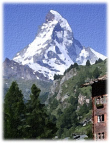
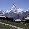
In bad weather, if necessary, retreat back to Zermatt or the shelter of one of the mountain restaurants or lift stations. Forecasts on the internet for the village of Zermatt, and a forecast for the high mountain trails above Zermatt (for Gornergrat 3100m/10,135ft). Special Walk Recommendations:Mountain Views: All of the walks have very nice
views, but for the most outrageous, jaw dropping views, I
recommend these in fine weather: the Gornergrat Descent, Ober
Rothorn, Hörnli Hut, Höhbalmen,
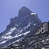
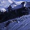
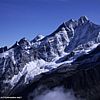
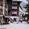
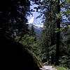
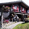
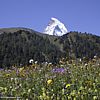
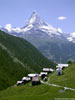
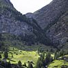
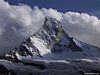
and to the Schönbiel Hut. Some Visual Highlights of the walks:Click on the photos to see a larger version of the photo. Click on a text link to take you to the appropriate walk description. |
| Don't forget to use the large map for orientation. |
|
.jpg)