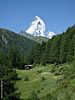
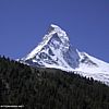
Description: A well
prepared path leads uphill through scattered forests and summer pastures
to a beautiful and ancient mountain hamlet. Three pleasant mountain
restaurants invite one to break the walk in Zmutt. This walk features
almost constant views to the Matterhorn and is justifiably popular - in
every season.
Time required: About 2 hours of walking
(70 mins uphill at start / 50 mins downhill)
Difficulty: **
Modest
Popularity:
*****
Very Popular
Begins at: Zermatt (1614m altitude)
Ends at: Zermatt
(1614m)
Goes via: Zmutt (1936m)
Track Notes: This broad footpath is in very good condition.
Any walking or sports shoes should be suitable. Trail open all year.
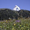
There are fine fields of wildflowers in the pastures before Zmutt,
especially mid-May to the end of June.
Nb. Zmutt is pronounced 'Zm-oot' rhyming with 'foot'.
Variants: This walk can be extended with the walk to Zum
See and Blatten, after visiting Zmutt. Alternatively, if you find
yourself fascinated by the impressive north face of the Matterhorn, one
can continue on towards the Schönbiel
Hut to make a big day of it.
The walk begins at the “Gemeinde Zollhaus” (Customs
office) at the southern end of Zermatt, just by the river and not far
from the Matterhorn lifts (“Matterhornbahnen”). To get to the
Zollhaus; find the river flowing north through the center of Zermatt,
and take the road upstream and alongside so that the river is on your
left. Ie. You want to be on
the west bank.
The Zollhaus is about a fifteen-minute walk from the main train station
of Zermatt, next to the river and the electric bus depot. A wooden
footbridge crosses to the other side of the river and the Matterhorn
lifts, and by the bridge is a big signpost indicating trails in all
directions. We continue on the road upstream in the direction of Zmutt.
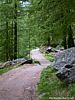
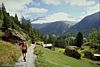
Walk further along the road to some park benches and a public
telescope with a view of the Matterhorn. Just beyond this, pass to the
right side of a quarry/gravel pits onto a broad footpath. A fenced path
ascends gradually through pleasant pasture (photo left) in the direction
of the Matterhorn. After five minutes take a right at an intersection
(1645m) in the direction of Zmutt. The path ascends to the right through
stands of trees and past barns to another intersection (1705m). At this
one take the upper right on in the direction of Zmutt again.
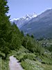
Fine views can be had behind to the Mischabel group of peaks
(photo left) - the Täschhorn, and Dom. Shortly the Breithorn can
be seen over the village of Zum See to the left. The Matterhorn begins
to fade from view as one climbs the path higher. A zigzag or switchback
goes by a stand of trees before the trail swings west again and flattens
out a bit. Pass a couple of pleasant chalets before reaching another
intersection (1910m). At this stage the village of Zmutt is in sight
ahead. Go straight on past the restaurant Edelweiss (not to be confused
with the more famous restaurant Edelweiss
on cliffs above Zermatt) and in five minutes the hamlet of Zmutt (1936m)
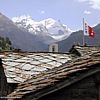
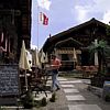
is reached amongst very fine pastures and wildflowers. In the village
can be found a charming little chapel, and two nice restaurants: the
Jägerstuße and Zmutt. The hamlet of Zmutt features many fine old barns
and wooden houses. Some old residents of Zmutt apparently never even
visit Zermatt. They feel it is too much like the "big city"!
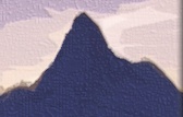
Tip:
From Zmutt itself only the tip of the Matterhorn is visible. If you want
an unobstructed view of the impressive north face, it is possible to get
a good view with an extra 15 minutes of walking. To do so turn right by
the Jägerstuße and
continue uphill on the path north out of Zmutt. Shortly the path
swings left (west) and a large dam can be seen straight ahead. Walk
along the path on a gentle uphill gradient until the north wall view of
the Matterhorn is unobstructed - which is about when you are above the
far end of the dam (photo
left).
Return to Zermatt at leisure the same way.
[ top of page
]