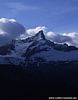
Description: This
beautiful walk features fine views to the Matterhorn and all of
Zermatt's other great peaks. A long, but moderate descent takes one through a vast
diversity of alpine environments; from rocky tundra, to high alpine lakes and
pastures, through peaceful forests, even by some fine mountain
restaurants. Wildlife of all descriptions can be abundant on this walk, especially in the
early mornings and evenings.
Time required: About three hours walking
(all downhill), plus about 45 minutes on the Gornergrat train
ascent.
Difficulty:
***
A long moderate
descent
Popularity:
****
Popular
Begins at: Gornergrat
(3100m altitude)
Ends at: Zermatt (1620m) Goes
via: Rotenboden (2815m), Riffelalp (2222m), Winkelmatten (1670m)
Track Notes: The top
section of this descent - from Gornergrat to Rotenboden - can be crowded
with casual walkers in July and August (***** popularity). After Rotenboden however the trails
become progressively quieter. To have this walk all to yourself - even
in July/August, try
walking early morning or in the evening after 5 or 6pm. As an added
bonus, there is almost the certainty of seeing lots of wildlife at
these times.
Be prepared for potentially cold and breezy conditions on the upper part
of this walk. Equally suncream may be a necessity. Be prepared for every
eventuality, although this walk does offer good views to the west where
the prevailing weather comes from.
Gornergrat train costs - one way trip: Adults: sFr.43
Children 6-16: 50% off. Children up to 6: free. ID required
for children's prices. Also discounts for holders of SwissRail Pass and Half Fare cards (50% off).
Variants: Using the Gornergrat train it is possible to break
your journey at any of the intermediate stations should you wish
(Riffelalp, Riffelberg, Rotenboden). Although there is no great
necessity to do so as you will walk nearby all of them in the descent.
The walk begins in the mountains at Gornergrat
(3100m altitude). To get up to Gornergrat from Zermatt you can walk of course (5
hours uphill), but for this walk we recommend taking the train in order
to save time and energy.
The Gornergrat railway ('Gornergratbahn') is located directly
opposite the main train station in Zermatt. Buy
your tickets to Gornergrat and
wait for a train. Trains normally depart every 24 minutes, and take
about 45 minutes to ascend to Gornergrat.
The view from Gornergrat station
(3090m) is simply magnificent - certainly one of the finest mountain
panoramas anywhere in the world. Eyes can feast upon uninterrupted views
extending for 180 glorious degrees from Monte Rosa to the Matterhorn
(photo below).
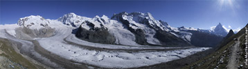
The magnificent panorama from near
Gornergrat.
Available in Half Size
- 86kb or Full size
- 262kb
For fine views in all directions, walk uphill for five
minutes past the big hotel and restaurant, to the gentle rounded summit
of Gornergrat (at 3130m). Benches, telescopes and maps naming the
various mountains are all on hand.
When
ready, walk back down to the railway station. Behind the station a
signpost points downhill to Rotenboden, Riffelalp, and Zermatt. Follow
the trail downhill, next to the railway track, in the direction of the
Matterhorn. The
first section of this walk - from Gornergrat to Rotenboden and the
Riffelsee lakes - is very popular. Consequently there are paths
descending everywhere. Simply take any path down, keeping the railway
line in sight to your right. After a few minutes reach a three way intersection, and take
the left to Rotenboden. This wide trail stays to the left of the railway
line, and in another minute goes over a gentle rise. The view opens up
below to the little peak of the Riffelhorn and the lakes of 'Riffelsee'.
We are aiming for the lakes, so proceed with any of the well used paths
downhill. The trail zigzags down a short rocky section.
Approaching
the lakes, the tiny railway station of Rotenboden is passed above to your right.
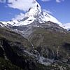
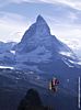
Continue on any path to the lakes (2757m). Fine photos of the Matterhorn
can be had in the lakes' reflection, but only if there is no breeze to
ruffle its surface. Early mornings are best for this.
Continue
on to the second lower lake by any path, walking under the rocky wall of
the Riffelhorn. Just past the second lake there is an unmarked
intersection. Take the left path descending. The trail goes down
gradually a few more minutes before another three way intersection.
Again take the lower path to the left in the direction of the
Matterhorn.
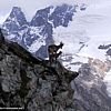
Keep
your eyes peeled for Steinbok, Ibex, marmots and other wildlife from now
on. The path descends through a pleasant mix of rolling pasture and
rocky outcrops for about ten minutes to another three way intersection
("Gagenhaupt" - 2565m). Take the left path and after a bare
100 yards/metres come to another three way intersection. Take the lower
left in the direction of the 'Gornergletscher' and Riffelalp. Walk
around a big rocky outcrop.
The
path then becomes a delightful single track as it traverses a very steep
high alpine pasture. Far below to one's left are the rushing waters of
the 'Gornera' river, which has come from under the Gorner glacier.
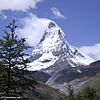
Always towering overhead is the Matterhorn, and there are fine views
ahead across the valley to the Dent Blanche, Gabelhorn massif, Zinal Rothorn, and
soon after to the beautiful white pyramid of the Weisshorn.
After
another kilometre the path reaches an 'X' intersection. Take the left
font route in the direction of Riffelalp, Ritti and Zermatt. After a few
more paces Zermatt itself can be clearly seen below, as well as the lift
station of Furi further up the valley. The path curves around to the
right and fine views can be had north over Riffelalp to the Täschhorn
and Dom.
Soon
the path drops steeply towards Riffelalp in a series of zigzags and
steps, before levelling out at the treeline. Cross a small stream or two
before the
path parallels another trail immediately below. The two trails meet by a large wooden
sign advertising the 'Chämi-Hitta' restaurant.
Indeed that is where we are aiming, so take a steep narrow trail as it
descends to a four wheel drive track (piste in winter). Follow this wide
clearing the last few hundred yards down to the Chämi-Hitta.
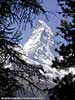
The Chämi-Hitta (2114m) is a truly charming
little restaurant with superbly intimate view across to the Matterhorn.
The
path goes left by the Chämi-Hitta
with a signpost by a cross. Descend on a broad footpath another ten
minutes through delightful forest , until reaching another broad grassy
slope (winter piste). A sign points in the direction down the slope to
Ritti. The piste turns left very soon, passing another sign, before
another sign points the way into the forest onto a footpath again in the
direction of Ritti's. The broad path continues its downhill journey
through zigzags and forest to a clearing and the charming restaurant
Ritti (1900m).
Continue
to the right of the restaurant onto another series of steep zigzags
descending through the forest, until one reaches the tarmac of the
Furi-Zermatt road (1800m). A sign points to the continuation of the
footpath just across the road in the direction of 'Moos'.
More
zigzags descend downhill through the forest until another clearing
cutting through the forest
(piste in winter). Take a right turn (north) onto the 'piste' in
the direction of 'Moos'. Continue straight on the piste/four wheel drive
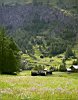
track, passing barns and pastures until shortly reaching the tarmac road
again. A signpost points downhill in the direction of Winkelmatten.
Follow the road as it winds gently down past the restaurant Moos, past
more barns and pasture to Winkelmatten - which is an outskirt of
Zermatt. Cross the big road bridge to the north. From the nearby
restaurant Waldhaus one can go right through Winkelmatten to Zermatt or
continue straight past the restaurant and onto Zermatt via the 'Matterhorn' lift
station ('Matterhornbahnen'). A multitude of paths lead back to the
center of Zermatt from
Winkelmatten, none much longer or prettier than any other.
[ top of page
]

.jpg)