Description: This
stunning hike has it all: unbeatable views to the Matterhorn north wall,
excellent views to most of Zermatt's other big mountains. There are
wildflowers, wildlife, and a real wilderness feel to most of the trail.
There are even some nice mountain restaurants towards the beginning and
end of the walk. Without a doubt this is one of the finest mountain hikes in the
Alps and indeed, the whole world.
Time required: About five hours
(3 hours uphill at start
/ 2Ľ hour downhill)
Difficulty:
***
Long and steady
uphill
Popularity: **
Quiet
Begins at: Zermatt (1620m altitude)
Ends at: Zermatt
Goes via: Edelweiss (1961m -
1 hour walk from Zermatt), Trift (2337m - 2 hours), Höhbalmen (2665m -
3 hours), Zmutt (1936m
- 4ľ hours)
Track Notes: Good shoes are required for some loose rocky
sections. A picnic among the heights of Höhbalmen can be recommended in
fine weather.
But be sure to take a wind and waterproof jacket on this hike. On the Höhbalmen
heights, you'll find no shelter from poor weather. Also beware of the shaggy mountain sheep on the higher reaches of this walk.
Some of the rams can be surprisingly aggressive.
This hike to Höhbalmen is sometimes also called the 'Edelweiss Way' or
'Edelweissweg' in german.
Variants: It is possible to extend this walk to the
Schönbiel Hut from the intersection just by the big
waterfall.
The walk begins and ends in the center of Zermatt's main street
(1620m altitude), just by the very well known Hotel Post complex and Grampi's Pub. You can find them in the main street, just 130 yards back
down from the church towards the main railway station out of Zermatt.
Opposite the Hotel Post is Grampi's Pub. A small cobbled laneway borders
Grampi's Pub and leads off the main street uphill to the west. An
inconspicuous signpost on the (laneway) wall of Grampi's also points
uphill in the direction of Edelweiss, Trift, etc.
Begin
up the cobbled path behind Grampi's for 60 yards to a three way
intersection. Continue straight on uphill past barns and smart wood and
glass chalets as the path loops around past the smart new "Into the
Hotel". Shortly beyond that the path reaches welcome pastures with
a fine view to the right of the Mischabel group of peaks (Täschhorn,
Dom). A few minutes of walking up through the fields brings one to a
four way intersection (1720m). Take the highest path (right) to
Edelweiss. The path ascends very steeply with the rushing waters of the
Triftbach (Trift brook) below to your left. As one climbs higher there
are clear views up to Edelweiss restaurant perched on its cliff top
eyrie.
Nb. Edelweiss restuarant is sometimes marked as 'Alterhaupt' on local maps.
After
another few minutes another intersection (1780m) is reached below some
cliffs. Take the left path to Edelweiss and shortly the path crosses the
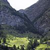
Triftbach below a gushing waterfall. The trail threads through
forest and continues steeply upwards via zigzags between a series of
cliffs. Just below the largest cliff on which the restaurant Edelweiss
perches is a good area for rock climbing. Beyond that one quickly
reaches the restaurant (1961m). Edelweiss offers snacks, drinks,
and meals. There are terrific views from the restaurant terrace over
Zermatt and (left to right) on to the Täschhorn, Dom, Unter Rothorn,
Gornergrat and Breithorn.
The
second section of this walk is that to Trift (2337m), which is a further
hour beyond Edelweiss restuarant. This section of the trail follows the rushing
waters of the Triftbach up the the narrow and rocky Trift valley.
Behind the restaurant Edelweiss, a signpost at the three way intersection
points uphill (west) in the direction of Trift. Begin by walking through
a beautiful little pasture before the trail enters a magical mountain
forest. Thankfully the trail is actually flat for a while here to give
the legs a bit of a break from the relentless uphill nature of this
walk.
After
while the path does a zigzag through a cliff above the Triftbach, before
crossing a bridge by a waterfall and a small hydro electricity outflow .
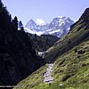
On the north bank of the Triftbach now, the path continues its steady
ascent west. Soon the view begins to open up - first to see the crown of
the Wellenkuppe, then to its left the Ober Gabelhorn, and finally to
their fine glaciers at the head of the Trift valley.
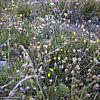
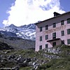
Trift
itself (2337m) is a delightful pastureland of wildflowers,
marmots and mountain streams. Being protected from winds, it makes a
fine place to stop for a break. The Trift hotel and restaurant offer
walkers a place to lunch in July and August, but equally fine is a picnic by one of the
crystal clear mountain streams. Trift is already very tranquil, but
beyond Trift, this walk engenders a wonderful feeling of remoteness.
From Trift to the Chalbermatten
restaurant three hours walk away, you'll be beyond all human habitation.
From
Trift the trail ascends the steep grassy hillside to the south. A signpost behind the Trift hotel indicates
'Höhbalmen'.
Cross the lovely Triftbach by one of several bridges and walk south to
the hillside. The path rises rapidly above Trift via a series of zig
zags, before traversing gradually uphill (south east). As one climbs
higher the views begin to take one's breath away. Firstly back west
towards the Gabelhorns and Wellenkuppe, then east to the Dom,
Täschhorn, Alphubel, Rimpfischhorn, Strahlhorn..
Rounding
a corner one reaches the large terraces and plateaus of the Höhbalmen.
Views west to the Gabelhorn fade rapidly, but are replaced by an
unobstructed panorama east to all of Zermatt's great mountains and
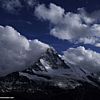
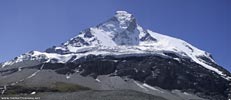
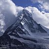
perhaps most impressively - to the north wall of the Matterhorn. The
views from here are simply magnificent. Be
alert for wildlife for the next 90 minutes of this walk. This is one of the best areas around Zermatt for seeing Ibex,
Steinbok, mountain sheep, and Stone Eagles. But beware walking amongst the mountain sheep in this area. Some
of the rams can be surprisingly aggressive.
The
trail then rambles across a pleasant mix of rocky scree and high alpine
pasture directly south towards the awesome North Wall of the
Matterhorn, until a branch in the path
is reached by a park style bench. The left path descends directly and
very steeply to
Zermatt. Take the right path straight on to a corner with an
unbeatable view to the Matterhorn (good spot for a picnic).
Beyond that the trail continues for 40 minutes in an easy and
interesting traverse in a westerly direction far above the Zmutt valley,
all the while with impressive views across to the north wall of the
Matterhorn. The path skirts below the faces of the Gabelhorns to your
right and crosses pasture, tiny streams and fields of rubble and scree
before descending south in a few easy zigzags towards the valley
floor.
At the bottom of the zigzags the trail reaches a flat section
by a stream and another intersection (2327m). Take the path left (east) back in
the direction of Zmutt and Zermatt. Variant: continue right (west) upstream to
the beautiful Schönbiel Hut at the end of the Zmutt valley.
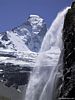
Heading back to Zermatt, the path descends immediately beside
a plunging waterfall of great beauty - one of the most attractive in the
whole area (photo left). The path is relatively indistinct by the
waterfall - simply descend by the waterfall. At the valley floor the
path can be found turning left (east & 2240m altitude). From now
on, the path follows the broad Zmutt valley the whole way back to
Zermatt in a leisurely downhill stroll. From the base of the waterfall
the trail makes its way through light larch forest on a pleasant
easy trail (1 mile/1˝ km) east to
Chalbermatten - marked by its single restaurant (2105m).
Another kilometer along the path passes above a dam and
beyond that reaches a four way intersection (1972m). Continue straight
on through down in the direction of Zmutt, which is reached in another
10 minutes. Zmutt is a beautiful and ancient mountain hamlet (1936m) set
amid very
fine pastures and wildflowers. In
the village can be found a charming little chapel, and two nice
restaurants: the Jägerstuße and Zmutt. The hamlet of Zmutt features
many fine old barns and wooden houses. Some old residents of Zmutt
apparently never even visit Zermatt. They feel it is too much like the
"big city"!
From Zmutt to Zermatt is a straight forward downhill ramble
of 50 minutes or less, often quite busy with walkers in July and August.
[ top of page
]
.jpg)