Description: This
short but satisfying adventure ascends 'the highest peak that
is possible to be climbed in Europe without a mountain guide'. The
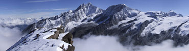
360ş panorama from the top is certainly one
of the finest views in Zermatt and the Alps.
Thirty-eight four-thousand meter peaks are visible from the Ober Rothorn, including particularly fine close up views to the Täschhorn, Dom and
Alphubel. Utilising some mountain lifts, it makes for a relatively
fast and spectacular summit hike.
Time required: About two and a half hours walking
(1˝ hours up / 1 hour down), plus about 1 hour using the mountain lifts
Difficulty:
****
A high
summit
Popularity:
***
Begins at: Unter Rothorn or 'Lower Rothorn' (3100m altitude)
Ends at: Unter Rothorn Goes
via: Ober (Upper) Rothorn (3415m)
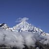
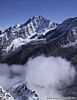
Track Notes: Good shoes are required for this steep and rocky
hike. Because this is a very high altitude walk, be prepared for
potentially cold and breezy conditions on this walk. Over summer this
walk should be snow-free, but as these photos from mid-July can attest, there is the
possibility of encountering snow on the walk at any time of year.
It is
never recommended to attempt this walk in bad visibility or in very
slippery or snowy conditions. The trail
is never too far from a precipice on the top third of the walk.
Because of the close proximity to the mountain lift station, this walk
is quite popular. If you want the trail all to yourself, try catching
the first lift in the morning from Zermatt, or catch the last lift and
walk the whole way down from Unter Rothorn (an extra 3 hours).
Unter
Rothorn lift costs - return trip: Adults: sFr.67 Children 9-16: 50% off. Children up to 8: free. ID for
children's prices required. Also discounts for holders of SwissRail Pass and Half Fare cards (50% off).
Variants: Using the mountain lifts it is possible to break
your journey at either of the intermediate lift stations (Sunnegga,
Blauherd). This Walking Guide includes a short easy stroll (1 hour
return) through the forests from Sunnegga to
Tufteren.
The walk begins and ends high in the mountains at the Unter
Rothorn lift station and restaurant (3100m altitude). To get up to
Unter Rothorn from Zermatt you can walk of course (4 hours uphill), but
for this walk we recommend taking a few mountain lifts in order to save
time and move quickly over some slightly ugly sections of ski pistes
(especially above Sunnegga).
We make use of the Sunnegga underground express lift for the
first part of the ascent. You can easily find the Sunnegga lift station
in Zermatt by looking for one of a multitude of signs pointing towards
the "Sunneggabahn" (Sunnegga railway). Alternatively follow
these directions for the five minute stroll from the main train station:
Across the street from the main train station is the valley terminus of
the "Gornergratbahn" (Gornergrat mountain railway). Follow the
street which runs next to the glassed in queuing areas for the
Gornergratbahn, and continue on this road as it follows the "GGB"
tracks for 250 metres to a busy intersection by the river. Cross the
river, going under the railway bridge and then take the first left
alongside the river downstream 100 metres to the Sunnegga lift station.
Buy
your tickets to Unter Rothorn (sometimes known in marketing speak as 'Rothorn Paradise") and walk the long
(and very cold!) tunnel
to the Sunnegga underground train. Trains leave normally every 20
minutes. After whistling up the mountain, exit the Sunnegga lift station
(2288m). Enjoy the nice panorama by the restaurant if you wish, before
taking the next Gondola lift to Blauherd. Watch for Marmots from the
Gondola, before disembarking at Blauherd (2570m), which I must say is a
much prettier place in winter. Jump on the cable car the final
quick stretch to the rocky rounded peak of Unter Rothorn.
Enjoy
the impressive view from the Unter Rothorn ('Lower Rothorn'), but
remember the view from the Ober Rothorn ('Upper Rothorn') is even more
spectacular.
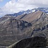
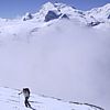
From the cable car terminus at Unter Rothorn, walk by the
restaurant and It is possible to see the first half of the track
up the nearby Ober Rothorn, as it skirts up the south flank. Walk downhill 10 minutes east in the direction of the Ober Rothorn
(photo). This very wide section down is a busy piste in winter. Arrive
without drama at the broad 'Furrgji' saddle (2980m). At the junction a
signpost points the way to the Ober Rothorn.
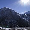
The
path ascends uphill east for half an hour, before a rocky shoulder where
it turns left (north). The path zigzags up a steep rocky slope until
nearing the edge of the northerly cliff faces of the Ober Rothorn. By
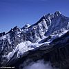
now there are superb views east to the nearby Rimpfischhorn (4200m) and
Strahlhorn (4190m). Before the cliff edge, the path turns west on a
further series of zigzags. These take take one close to the summit
ridge, from where the summit itself is achieved in another 15 mins or
so.
Panorama from Ober Rothorn 360°.
Available in Half Size -
150kb or Full size - 371kb
From
Unter Rothorn, the Ober Rothorn appears little more than a very steep
rocky hill, however attainment of its summit reveals it to be an
impressive mountain in its own right, with a huge north wall falling
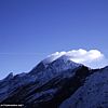
thousands of feet into a deep ravine above Täschalp. From the summit of
the Ober Rothorn (3415m) there are magic 360ş
views to all of Zermatt's great mountains - especially north to the
nearby giants of the
Täschhorn, Dom, Alphubel, Rimpfischhorn, and Strahlhorn.
Return
to Unter Rothorn and Zermatt the same way.
[ top of page
]