Description: This hike
ascends steeply to the Rothorn climbers' hut. Hikers are rewarded with
excellent mountain scenery up Zermatt's most remote (and steepest) mountain valley. The
walk passes through a vast altitude range. Consequently the climate and
scenery is very diverse: from warm forests, pastures, and wildflowers to
rocky alpine wilderness and spectacular glacier scenery. There is also a
good chance of seeing wildlife.
Time required: About seven hours
(4˝
hours uphill at start
/ 3 hour downhill)
Difficulty:
****
Long steep uphill
Popularity:
*
Very quiet
Begins at: Zermatt (1620m altitude)
Ends at: Zermatt
Goes via: Edelweiss (1961m -
1 hour walk from Zermatt), Trift (2337m - 2 hours), Rothorn hut (3200m -
4˝ hours)
Track Notes: Good shoes
are required for very long and steep rocky sections. Being a high
mountain walk, be prepared for
potentially cold and breezy conditions on this walk. There is also the possibility of encountering snow towards
the hut.
On this walk expect very little visual warning of weather changes,
due to the wall of mountains blocking views to the west. Unfortunately
that also means clouds can arrive without warning to block
views. It is not recommended to ascend beyond Trift in bad weather.
Watch for wildlife - especially at Trift and during the walk for 45
minutes above it. Marmots, Ibex, and mountain goats can often be seen -
especially mornings and evenings.
Variants: Stay at the Rothorn
Hut for a memorable night with the climbers (100 dormitory beds -
sFr.24. Plenty of blankets provided. Breakfast and dinner available.
Phone 027 - 967 2043). Optionally continue the next day from the hut via
Trift to Höhbalmen and the Schönbiel Hut
for a superb 2 or 3 day high mountain adventure.
The walk begins and ends in the center of Zermatt's main
street (1620m altitude), just by the very well known Hotel Post complex
and Grampi's Pub. You can find them in the main street, just 130 yards
back down from the church towards the main railway station out of
Zermatt. Opposite the Hotel Post is Grampi's Pub. A small cobbled
laneway borders Grampi's Pub and leads off the main street uphill to the
west. An inconspicuous signpost on the (laneway) wall of Grampi's also
points uphill in the direction of Edelweiss,/Trift, etc.
Begin
up the cobbled path behind Grampi's for 60 yards to a three way
intersection. Continue straight on uphill past barns and smart wood and
glass chalets as the path loops around past the smart new "Into the
Hotel". Shortly beyond that the path reaches welcome pastures with
a fine view to the right of the Mischabel group of peaks (Täschhorn,
Dom). A few minutes of walking up through the fields brings one to a
four way intersection (1720m). Take the highest path (right) to
Edelweiss. The path ascends very steeply with the rushing waters of the
Triftbach (Trift brook) below to your left. As one climbs higher there
are clear views up to Edelweiss perched on its cliff top eyrie. Nb.
Edelweiss is shown as 'Alterhaupt' on some local maps.
After
another few minutes another intersection (1780m) is reached below some
cliffs. Take the left path to Edelweiss and shortly the path bridges
over the
Triftbach below a gushing waterfall. The trail threads through
forest and continues steeply upwards via zigzags between a series of
cliffs. Just below the largest cliff on which the restaurant Edelweiss
perches is a good area for rock climbing. Beyond that one quickly
reaches the restaurant (1961m). Edelweiss offers snacks, drinks,
and meals. There are terrific views from the restaurant terrace over
Zermatt and (left to right) on to the Täschhorn, Dom, Unter Rothorn,
Gornergrat and Breithorn.
The
second section of this walk is that to Trift (2337m), which is a further
hour beyond Edelweiss. This section of the trail follows the rushing
waters of the Triftbach up the the narrow and rocky Trift valley.
Behind the restaurant Edelweiss a signpost at the three way intersection
points uphill (west) in the direction of Trift. Begin by walking through
a beautiful little pasture before the trail enters a magical mountain
forest. Thankfully the trail is actually flat for a while here to give
the legs a bit of a break from the relentless uphill nature of this
walk.
After
while the path does a zigzag through a cliff above the Triftbach, before
crossing a bridge by a waterfall and a small Hydro electricity outflow .
On the north bank of the Triftbach now, the path continues its steady
ascent west. Soon the view begins to open up - first to see the crown of
the Wellenkuppe, then to its left the Ober Gabelhorn, and finally to
their fine glaciers at the head of the Trift valley.
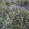
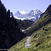
Trift
itself (2337m) is a delightfully intimate and untouched pastureland of wildflowers,
marmots and mountain streams. It is protected from winds and makes a
fine place to stop for a break. The solitary old Trift hotel/restaurant offer
walkers a place to relax, but equally fine is a picnic by one of the
crystal clear mountain streams. Trift is already very tranquil, but
beyond this the walk becomes a truly remote one. Very few hikers go
beyond Trift.
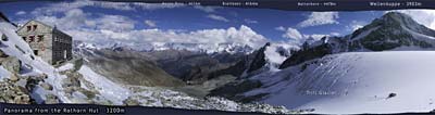
Be
sure to have a look at the photomap
of the upper section of the walk from Trift to the Rothorn hut.
From
behind the Trift hotel, a signpost points in the direction of the
Rothorn hut. Follow that path uphill a few minutes to another
intersection (2397m). Take the left path in the direction of the Rothorn
hut. The trail ascends a steep hillside via a series of zigzags before
flattening out at another plateau. A last intersection (2453m) is
reached in the trail. Take the left to the Rothorn hut. From here it is
still over two hours to reach the Rothorn hut. Already one feels quite
high, but this point is still only half way to the hut from Zermatt..
By
now the peaks of the (left to right) lower, middle and upper Gabelhorn,
Wellenkuppe and Trifthorn are truly towering straight overhead.
Behind you there are fine views back to Monte Rosa, Liskamm, and
the Twins. From this position here it is just possible to make out our
destination ahead.. there are three distinct glaciers in view. From the
left, between the second and third glacier is the big grey spine of a
lateral moraine. The trail ascends this pile of rocky rubble to its top,
from where just above and to the right - under a big brown rocky outcrop
- lies the hut. It is not easily seen due to its construction out of
local stone. Look for its man made shape giving it away.
The
path ascends through the rubble of a moraine with fine views left to the
beautiful snow domes of Unter and Mittler Gabelhorn. After 15 minutes
the trail reaches something of a flat flood plain, criss-crossed by
streams. The moraine to be climbed is visible immediately to the left
and shortly one begins the relentless and grindingly steep rubble path
to the hut. This part of the track really puts a strain on the calf
muscles due to its unforgivingly steep uphill gradient.
As
the trail rapidly ascends it brings into view some incredibly
spectacular glacier and icefalls to the left. The path zigzags
relentlessly up the rocky moraine, until after an hour of steep
climbing, the tip of the Matterhorn becomes visible to the left (south).
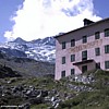
The hut itself then shows itself as a welcome sign and the final few
hundred metres of trail are relatively gentle.
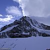
From
the Rothorn hut there is a fine unobstructed 90ş panorama
of Zermatt's big peaks. Views east encompass the Alphubel all the
way round to the Klein Matterhorn. The tip of the Matterhorn is still
visible, and the Wellenkuppe towers over the nearby Trift glacier (photo). A
hundred metres from the hut lies the edge of this beautiful glacier.
Creaks and groans can often be heard as the ice cracks and grinds its
way downhill. Do not stray on to the ice without appropriate equipment
and/or expert local guidance - there are hidden crevasses.
Drinks
and (normally) meals are available at the hut, but they are not cheap.
Everything has to be brought in by helicopter.
It can be quite an experience to stay at the hut and chat with the brave
mountain men. Bring warm clothes for the very cold evenings. Sun rises
are spectacular from the hut. Due to the very high altitude, many people
do not experience a perfect night's sleep. Be sure to drink plenty of
fluids. It is very easy to get dehydrated at this altitude, even if the
weather is cool.
The
descent from the hut is very fast. It is possible to return to Trift in
an hour, and Zermatt in two hours - if one hurries. Being quite
steep, the descent is a bit of a test on the knees.
[ top of page
]